

 The Environment Agency says it's closely monitoring the South East coastline as the Met Office predicts high winds and heavy rainfall around the coast on Thursday evening (December 13) and into the weekend.
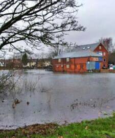
Pic: high tides at Woodmill on Friday, by Geoff Lea
Heavy showers are forecast across the South East on Thursday evening, and with a low pressure system expected to bring wet and stormy conditions to the south coast on Friday (14 December), the Environment Agency is working hard to minimise any possible risk of flooding and is warning residents to take action now to reduce the risks and impacts.
The weather system could bring gale force south-easterly winds, large waves, and a moderate storm surge during Friday and Saturday, which would coincide with the peak spring tides. Large waves and strong winds could result in minor disruption inland, with some impact from spray or wave overtopping.
Parts of Hampshire, the Isle of Wight, Sussex and Kent are forecast to receive up 10-20mm of rainfall tonight and tomorrow, which has the potential to cause minor disruption and lead to possible flood alerts being issued. Isolated areas may receive up to 30mm of rainfall.
Article continues after this message...